Decisions, Destiny, and Dreams: Plympton’s Reserve, St. Paul’s Founding, and Desnoyer’s New Bridge Square
- Year
- 2024
- Volume
- 59
- Issue
- Number 2, Spring 2024
- Creators
- Drew M. Ross
- Topics
-
- Agriculture & Farm Life
- Business
- Crime
- Early Minnesota
- Economics & Finance
- Environment
- Government & Politics
- Historic Site
- Immigration
- Law & Legislation
- Military History
- Mississippi River
- Native American & Indigenous History
- Saint Paul
- Saint Paul: Hamline-Midway
- Saint Paul: Lowertown
- Saint Paul: St. Anthony Park
- Saint Paul: West Seventh/Ford Road
- State Capitol
- Taverns & Bars
- Transportation

By Drew M. Ross
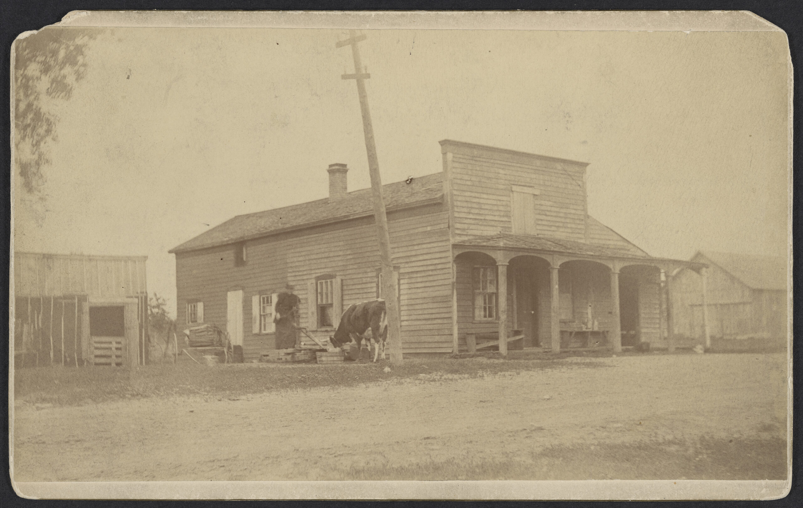
Tourists leaving St. Paul for St. Anthony Falls in the early 1850s might have traveled in one of Willoughby and Powers’ yellow Concord coaches across an undulating prairie interspersed with oak groves. Their first stop could have been Desnoyer’s Halfway House. There, they may have found their “short, rotund, [and] jovial” host pacing the veranda of his stage tavern, greeting visitors and talking up the value of his precious real estate.
A story was told of those old days of a visitor who asked Mr. Desnoyer how much his property was worth. “Oh, vell, I’se zinks one hundred tollars per acre,” he is noted by a contemporary as saying. When pressed for confirmation, Desnoyer proudly increased the value to $125 per acre. The man confirmed they were talking about Desnoyer’s hundreds of acres along the Mississippi River, and Desnoyer asked if the gentleman wished to buy the land. “No,” the visitor replied, before departing. When Desnoyer learned the inquisitor was the Ramsey County assessor who was setting the taxable value of the property, he realized his mistake. He is said to have jumped on his fastest horse and chased after the government official. When he caught up with him, Desnoyer “ ‘smiled,’ and the [a]ssessor ‘smiled,’ and they kept on ‘smiling,’ (for everybody ‘smiled’ in those days).” Eventually, the two reached a compromise—Desnoyer’s property was assessed at $25 per acre.
Introducing Etienne Deynoye(r), et al.
When Desnoyer arrived at the confluence of the Mississippi and St. Peter (Minnesota) rivers in the early 1840s, his poor English heavy with a Canadian-French accent, he was known as Etienne Deynoye—his last name spelled phonetically.
He was proud, and, perhaps, arrogant. He tended to be boastful and was as physically large as his overstated claims. One report called him “a shrewd Frenchman,” which may have been a “nicer” way of saying aggressive, combative—even underhanded. He knew whiskey could be anything a person wanted it to be—medicine, currency, or poison. He was a hotelier, a saloonkeeper, a trading post operator with Indians and soldiers, a land speculator, a farmer, and a horse racer. When he died intestate on December 3, 1877, he was Stephen Desnoyer. He was rich, and it was rumored that he buried some of his money on his property. While the supposed treasure was never found, he believed the land to be “treasure,” as he envisioned the development of a growing metropolis.
Desnoyer was born April 22, 1805, in Saint-Jean-d’Iberville, Quebec, about thirty miles southeast of Montreal. He was the oldest of seven children. In 1823, at eighteen, he moved up the St. Lawrence River and settled on the southeastern shore of Lake Ontario in Oswego, New York, where he worked as a farmer for four years.
He returned home, now and then, but his relationship with his father was tense. His sister, Mary Desnoyer Jardin, remembered her brother with a woman who drank excessively, and others said that another woman with whom he had a relationship was a Protestant. Either way, his Catholic father kicked him out. In the late 1830s, Desnoyer moved to Troy, New York—near the eastern terminus of the Erie Canal—and operated a mobile concession, selling groceries and liquor from a keelboat along the canal. He married Mary (Marie) Jarvey, and they had a son—John George Isaie. When Mary died in 1838, the infant was taken to live with family in Canada.
Desnoyer traveled west with his keelboat, a common cargo vessel at the time. Long and narrow like a cigar, these boats were used for hauling loads on lakes, rivers, and canals. He headed to Detroit and eventually made his way to the Mississippi where we find him in river towns such as Cape Girardeau, Missouri, and Prairie du Rocher, Illinois. The man was at heart a trader, and his boat was elemental to his business ventures as he transported lumber, clothing, grain, and other goods.
It wasn’t long before he married Maurice Doiron in Prairie du Rocher in 1839. The couple moved upriver to the rough lead-mining town of Dubuque in the recently organized Iowa Territory (1838), where he hauled lumber and lead ore. His wife died there on May 30, 1842, at twenty-eight, as did their three-month-old child, Etienne, on July 1.
Desnoyer moved on. He traveled north on the Mississippi toward a US military fort named for Col. Josiah Snelling, an early commandant there. It turns out, the widower was headed to his future home at exactly the right place and time—thanks to decisions and events that took place a few years earlier by Maj. Joseph Plympton, the commander of the fort from 1837 to 1841. Not only would Plympton’s decisions affect Desnoyer and his dreams; they would also determine the location and development of the eventual city of St. Paul.
Shaping the Settlement
The story of Fort Snelling has been told many times from many perspectives and involves many key players. For this article, however, we’ll provide a narrower focus.
When the US Army selected sites for their forts, they chose to protect waterways. Situating Fort Snelling below St. Anthony Falls at the confluence of the Mississippi and St. Peter rivers made sense. The rivers served as transportation routes, and the falls offered a power source. The problem was that, between the falls and the confluence, the Mississippi had cut a nine-mile gorge with a steep gradient that ran shallow and strong through an obstacle course of boulders and sandbars. Because the gorge was impassible to most steamboats, the confluence became, in effect, the head of navigation. Situated on the bluff, the fort could defend transportation routes, monitor the fur trade, and engage with the Native people whose land would soon be colonized. The ground directly below served as a premier boat landing in the upper Mississippi basin with calm water; provided accessible, flat land useful when unloading boats; and was a suitable access site to the fort above.
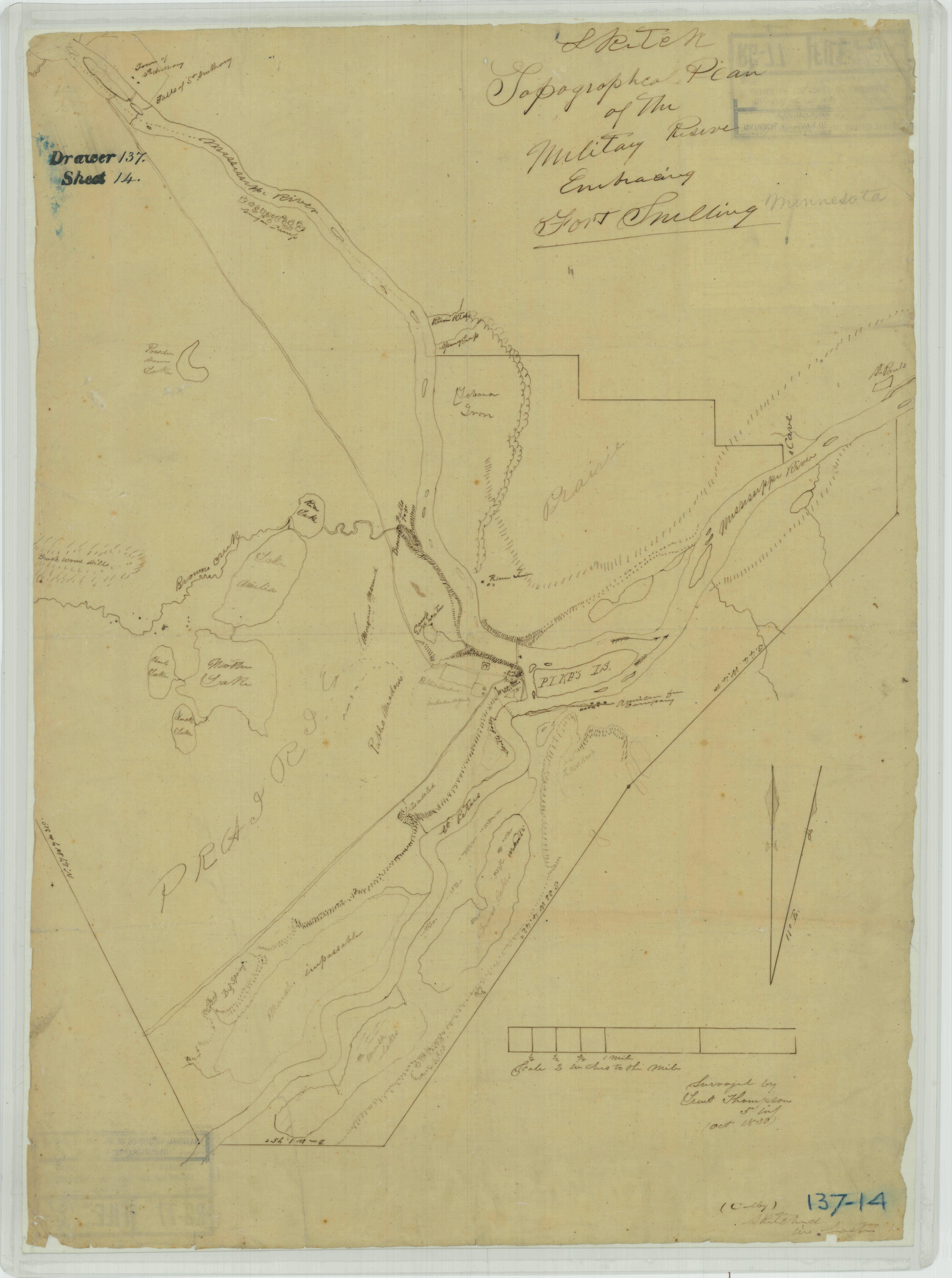
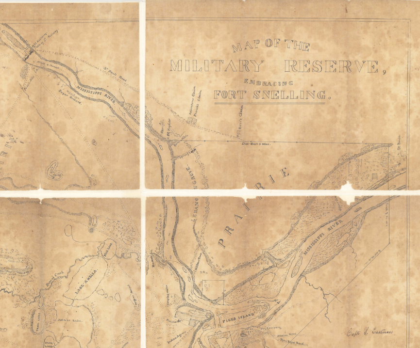
Two roads extended from the fort on the west side of the river. One followed the gorge to the government mills at the falls. The other road connected to lakes Harriet and Calhoun (today’s Bdé Makhá Ská). Early maps show road segments on the east side, as well. A ferry at the confluence allowed for easy crossing. The best roads were on the west side and used by soldiers and tourists alike. They foretold of future development, illustrating first efforts to bypass the gorge. But the roads were on the fort reserve, and as long as it was operative, the area was off limits for settlement.
Yet, naturally, the fort and its location attracted nonmilitary newcomers. People began to stake land claims near the confluence, opposite the fort on the east bank following cession of Native land in 1837. Some coming to the area understood the fort to be temporary, as was the case with other regional forts. For example, also in 1837, the US Army began releasing reserve land around Fort Dearborn, which soon led to that fort’s decommissioning. The city of Chicago grew rapidly in its footprint.
These settler-colonizers viewed Fort Snelling similarly as the natural center of a future metropolis along the upper Mississippi. The small settlement on the east side of the river became known as Rumtown (now Hidden Falls Regional Park), its name referencing the smattering of groggeries, which, like saloons, served as social meeting houses. Unsurprisingly, the proximity of the fort to excessive amounts of alcohol more than occasionally undermined the semblance of an orderly garrison. That was viewed as a problem.
Enter the previously mentioned Maj. Plympton. Along with the aggravation of drunken soldiers, Plympton, the new commander of Fort Snelling, faced other dilemmas in 1837. He insisted he was short on wood for fuel and pasture for livestock at the fort. He addressed these three issues with a singular solution: expand the Fort Snelling Reserve. Plympton petitioned the War Department in Washington, DC, which authorized his request. He enlarged the area in 1838 and again in 1839. Following the second expansion, Plympton ordered the reserve vacated of all occupants by force and ordered homes destroyed. His problems were solved. But what about those who had been evicted? Where did the drunkards (largely former soldiers and some Indians) and families (many emigrants from Red River Colony who had settled there for trading, protection, and, sometimes, speculation) go?
With the expansion of the Fort Snelling Reserve, Plympton eradicated the area’s primary settlement. Some of the displaced moved downriver along the river corridor on the east side. A few people settled near the easternmost boundary of the reserve (near today’s Xcel Energy Center in an area that was, for a time, called Seven Corners). The location fell short of ideal. The top of the bluff where they settled was rough, low-grade land saturated with bogs and swamps. At that time, steamboats headed to the fort never stopped at the bluff’s base to service the area. Yet, as rough as it was, this was the only location downriver from the fort where people could access the water from above. They had just one street (Jackson) that extended to the river. It was very steep, requiring a yoke of oxen to haul a single item, such as a barrel of whiskey or flour, up into town. As the settlement grew, steamboats did begin to stop there, but it was not a natural settlement site.
Father Lucien Galtier had been based in Mendota, serving the fort and its surroundings. With the reserve expansion and the community dispersal, the area’s first Catholic priest looked to build a chapel that would center and serve the inhabitants. He considered a few locations, including the largest community of forty families at Pointe Leclaire (La Pointe Basse) downstream (near today’s Pig’s Eye Lake). He ultimately chose the small settlement of displaced Red River farmers (among them Rondeau, Guerin, Bottineau, and Gervais) at the top of the bend primarily because the area did not flood. Nonetheless, the new chapel was built in a “tamarack swamp.”
It is clear Plympton had, whether by chance or intentional design, situated the residents in a disadvantageous area that had few beneficial features for a settlement, especially compared to the confluence. Yet, people made do, and, in time, the future city of St. Paul would become the new head of the navigable river.


Ulterior Motives?
Plympton’s solution to the problems of insubordination and acquiring natural resources missed the mark. Some of his contemporaries criticized the reserve, saying it was poorly laid out, unnecessary, and ill-placed. Others went further, accusing the major of an ulterior motive, that is, enhancing the value of land at St. Anthony Falls—where he had interest in staking a claim. In fact, around 1836, a year before the land cession, he had built a cabin on the east bank of the falls—some referred to it as Plympton’s Claim. Plympton was trying to protect that claim.
There’s compelling reason to believe army culture “allowed” officers to speculate in land. The commandant knew this and knew the area better than most. He was a career officer, having joined as a lieutenant in the War of 1812. He fought in the Northwest against the British and their allies and remained in the region for decades with the Fifth Infantry Regiment to build and manage the forts. In fact, as mentioned earlier, Plympton, had served for a time under Snelling when the fort was under construction in the early 1820s. Plympton had explored the area at that time. In other words, he had been onsite of his renown future claim seventeen years before the cession officially opened up the land.
Plympton’s son, Gilbert, later wrote a hagiography and touched on his father’s role in land speculation, which was illegal for an active military officer, although, as mentioned above, the military often turned a blind eye. According to Gilbert, as the last commander of Fort Dearborn in 1836, Plympton could have had “miles of land . . . [at] the very centre of Chicago.” He had many opportunities, but the military’s transient life “precluded him from availing himself of these opportunities, even if, at the time, he appreciated them.” Well—most of the time. While serving at another location, Fort Detroit, Plympton purchased “the best site for a town anywhere in that district.” He and an associate had it surveyed, laid out the streets, and divided the property into lots. The speculation failed. The family sold the claim after his death.
Plympton’s land speculation in Detroit may have bolstered his critics’ accusations that he expanded the Fort Snelling Reserve, at least in part, for self-interest. Regardless of the reasons, ultimately, Plympton’s manipulation of the reserve boundary distorted the settlement pattern, moving what could have become a city at the confluence of today’s Mississippi and Minnesota rivers downstream.
That’s one outcome of Plympton’s efforts, but don’t forget Stephen Desnoyer. Remember, he arrived a little later—in the early 1840s—after the reorganization of the reserve. And he, unlike some, clearly benefitted from Plympton’s decisions.

courtesy of Minnesota Historical Society.
Bridge Square Dreams
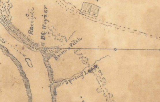
When Plympton extended the reserve, he drew its eastern boundary from St. Anthony Falls down the middle of the river to a bend near today’s Marshall Avenue, about halfway between the falls and the fort. At that point, the reserve boundary turned east, creating a northern edge of the reserve. It left the river at a drainage labeled Rum Pitch.
Enter Donald McDonald, a Canadian Scot, seasoned trader of the region, whiskey seller, and a translator at the fort. McDonald had no respect for Plympton, who reportedly had ordered McDonald’s first house at Rumtown destroyed. While most evicted reserve residents drifted downriver to the bluffs, McDonald went upriver and “subsequently . . . claimed the land” at Rum Pitch—opening up a tavern—just north of the reserve’s redrawn boundary. Perhaps, Plympton’s plan hadn’t worked after all.
Not long after, Desnoyer, having lost his second wife, arrived. He’d traveled upriver passing Pointe Leclaire with its voyageur encampments and St. Paul with its chapel perched on a bluff, a few log houses, grog shops, and trading posts. He continued past Fort Snelling and proceeded up the river gorge north of the Fort Snelling Reserve.
There, Desnoyer traded McDonald “a barrel of whiskey and two Indian guns” for the land and the tavern. That trade seems extraordinarily lopsided—so much land for whiskey and guns—but they were not trading for full value. The land had not been surveyed, so they were still considered squatters. “We were all called squatters,” noted one resident in one of the state’s early anthologies. In essence, Desnoyer traded for squatter’s rights—a land claim made by occupying the property preemptively. This enabled him to make a claim when the legal process opened. This black-market trade happened in a mostly cashless economy. When Minnesota became a territory in 1849 and the land was surveyed, Desnoyer would have paid $1.25 per acre.
Though not entirely clear, it is thought that Desnoyer briefly continued running McDonald’s former tavern at Rum Pitch, just above the river (near Town & Country clubhouse). This location, halfway between St. Anthony Falls and Fort Snelling, would have been the closest to the fort and soldiers looking for drink.
However, a rough road connected St. Paul with the falls, running through the northeast corner of Desnoyer’s property. He soon abandoned the original tavern and, likely by 1843, had built a new Halfway House along that road, complete with a sign above the door. This small move from river to road reflects a change in economic perspective: Desnoyer shifted his business to focus on the thoroughfare. Now on the St. Anthony Falls-St. Paul Road, the tavern was roughly equal distance to all three locations: Fort Snelling, St. Anthony Falls, and St. Paul. He either positioned himself or found himself at a local crossroads, and he quickly understood that “[h]e own[ed] a large number of acres of very valuable land.”
As population increased, Desnoyer was among several who envisioned that St. Paul (named the capital of Minnesota Territory in 1849 and incorporated as a city in 1854) and St. Anthony (1860) would unite as one. For example, early on, Henry M. Rice, the influential politician, predicted that the nearby communities “would form one great municipality.” Others agreed. “The time will come” when “the two cities will be united,” wrote a traveler in 1855. “This has been the case with other places and we see no reason why it should not be with ours.”
In 1872, however, it was the younger but growing Minneapolis (1867) that absorbed most of St. Anthony. Still, as development continued, Desnoyer firmly believed the location of his property would “become the Bridge Square of united Minneapolis and St. Paul.” Both locations had a bridge square—a town center along the river. If the two cities did, indeed, merge, many agreed that Desnoyer’s centrally located property was in good position to serve as the new Bridge Square.
Desnoyer was so confident in a merger that he claimed to have declined an offer of $100,000 for his property (about $2.5 million today). That’s $250 per acre based on 400 acres, double the exaggerated figure he gave the county assessor decades earlier. He refused the outsized offer, he said, because it did not capture the value he foresaw.
As we all now know, the cities never did unite.
Reflecting Back
Maj. Joseph Plympton created his reserve at a critical moment in the development of our embryonic state in the late 1830s. When Wisconsin became a state in 1848, its new boundary vacated the territorial status of the triangular piece of land between the Mississippi and St. Croix rivers, threatening the stability of their claims. The early settler-colonizers were now in an unorganized territory. What to do? Wisconsin statehood forced the organization of the Minnesota Territory because it still did not have 5,000 voters. In fact, at that time, the population of St. Paul amounted to a few hundred people. Still, the squatters at St. Paul had surveyed a town plat, an unconventional method as the government usually conducted the surveys, so they were ready in 1849 when the new Minnesota Territory needed a capital.
Rep. Henry Sibley wrote a bill to move the eastern border of Plympton’s reserve back to the Mississippi River at the confluence. The bill was introduced in the Senate in 1850 but did not pass until 1852. It would take a few years for the reserve to be surveyed, opening the first section in 1854.
Had the reserve’s size (with the confluence) been reduced and come up for sale before Minnesota gained territorial status, it may have produced different settlement patterns. Instead, by the time the reserve opened, St. Paul had roots, was home to over 4,000 residents, and, was in the midst of a speculative land fever with dozens of additions platted. There was no going back.
Ironically, Plympton’s reserve boundary inadvertently created a settlement at the best point for a land route to St. Anthony and the falls. From St. Paul, the river makes a large bend to the southwest, so a boat heading to Fort Snelling would finish its journey by traveling southwest the last seven miles. Fort Snelling was about nine miles from St. Anthony Falls, as was St. Paul. As the fort dwindled in influence and St. Paul surged in commerce, steamboat traffic shifted. With improved roads, stagecoaches initiated regular service in the early 1850s. The overland route to St. Anthony became the preferred route, further solidifying St. Paul’s role in the area. At first glance, this route might appear to be a natural response to the impassable gorge and development of boat landings at St. Paul, making it the head of navigation. However, just as with St. Paul’s location, the road was constructed in response to Plympton’s expanded reserve.
And what of Desnoyer? Desnoyer’s life was cut short in 1877. While returning from Minneapolis, “his spirited team of horses” threw him from his buggy, leaving him unconscious. He was carried home, where he survived about two weeks before succumbing to his injuries at seventy-three years old on December 3. Desnoyer was survived by a fourth wife, two sisters, and two children of a sister and a brother. The wife, Sarah (Sally) Johnson Desnoyer, operated the Halfway House as the estate went through probate court. Surprisingly, the court valued the holdings at $73,257.55, and the inheritors eventually sold the properties to investors for $100,000. Desnoyer’s early estimates he’d given to the assessor were not too inflated after all.
Desnoyer’s big idea did not die with him. Others continued to share his view of the future. They knew the land between the two logistical points of interest—the upper extremity of navigable water now at St. Paul and the scenic power source of the St. Anthony Falls—would fill in with residents. A quote from the Minnesota Weekly Times in 1856 had summed things up well:
We hope to live to see the day when the two cities will be united in wedlock and when the jealousy hitherto existing will be known only in history as once the play-thing of a disordered brain.
Twenty years on, people remained optimistic.
In a grand finale, a concerted effort by influential parties in the late 1880s and early ’90s advocated to locate a new capitol building and Catholic cathedral around Desnoyer’s property. But by then, Minneapolis and St. Paul had developed separate infrastructures and identities, and their rivalry, which continues to this day, would forever thwart efforts to create a single united city. The St. Paul neighborhood that bears Desnoyer’s name was platted in 1887 and stands on land that belonged to him. It includes a park of the same name and the Town & Country Club.
Additional Information:
For more information on the early Desnoyer Tavern, see “Stephen Desnoyer’s Halfway House”
For more information on the Desnoyer lawsuits and his third wife, Letitia, see “A Litigious Man: The Court Cases of Stephen Desnoyer”
Acknowledgment: Special thanks to James W. Oberly, professor emeritus of history at University of Wisconsin-Eau Claire, for providing insight over several drafts of the manuscript.
Drew Ross is a writer who lives in St. Paul’s Desnoyer Park. He is a coauthor of Walking on Sand: The Story of an Immigrant Son and the Forgotten Art of Public Service with Rocco C. Siciliano. He is currently writing a book for Minnesota Historical Society Press on the nineteenth-century efforts to unite St. Paul and Minneapolis.
- Year
- 2024
- Volume
- 59
- Issue
- Number 2, Spring 2024
- Creators
- Drew M. Ross
- Topics
-
- Agriculture & Farm Life
- Business
- Crime
- Early Minnesota
- Economics & Finance
- Environment
- Government & Politics
- Historic Site
- Immigration
- Law & Legislation
- Military History
- Mississippi River
- Native American & Indigenous History
- Saint Paul
- Saint Paul: Hamline-Midway
- Saint Paul: Lowertown
- Saint Paul: St. Anthony Park
- Saint Paul: West Seventh/Ford Road
- State Capitol
- Taverns & Bars
- Transportation